Projet Humpleu / Project Humpleu
Die Pestera Humpleu ist die zweitlängste Höhle Rumäniens. Bekannt seit Herbst 1984, erreicht sie inzwischen eine Länge von ca. 40 km. Da in den Anfangszeiten der Höhle viele verschiedene Grüppchen forschten, ist der Planstandard äusserst unterschiedlich. Felix Papiu, Gigi Fratila und Ovi Pop von Cluj befass(t)en sich mit der Erforschung und Vermessung der Höhle, leider mit wenig Unterstützung von den rumänischen Höhlenforschern.
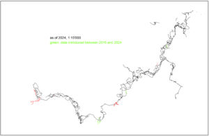
Um eine Nachvermessung der Höhle zu machen, gab es seit 2001 eine ursprünglich helveto-rumänische Zusammenarbeit, die mittlerweile international wurde: Proiectul Humpleu. Das Ziel des Projektes ist, die Höhle in Grund- und Seitenriss auf eine brauchbare Art zu vermessen. Brauchbar heisst in diesem Zusammenhang im Masstab 1:1000, dies einerseits, weil die Höhle sonst nie fertig wird (wenn überhaupt…), andererseits, weil die Hallen so riesig sind, dass ein grösserer Massstab die Höhle unübersichtlich machen würde…
Nach langer Wartezeit aufgrund von administrativen Hindernissen wurde 2024 die Nachvermessung endlich beendet! Doch noch gibt es Gänge, die noch nicht vermessen wurden, und dazu kommt ein grosses wissenschaftliches Interesse, so dass das Projekt weitergeführt wird.
Die Höhle ist hauptsächlich grossräumig und horizontal, ein Schacht von der Oberfläche her stellt den zweiten Eingang dar. Um in die hinteren Teile zu gelangen, muss im Bach (und in Halbsiphons) mit Neopren vorgedrungen werden.
Kontaktiert doch bitte Praezis bei Interesse – so werdet Ihr informiert, wann immer.
Projet Humpleu
La grotte Humpleu est la 2e en longueur de la Roumanie. Connue depuis l’automne 1984, elle atteint une longueur d’environ 40 km. Dans le début de l’exploration, beaucoup de groupes ont travaillé dans cette cavité, de ce fait, le standard des topos varie extrémement. Felix Papiu, Gigi Fratila et Ovi Pop de Cluj s’occupent de l’exploration de cette caverne. Malheureusement, ils n’ont pas beaucoup de support de leurs collegues roumains.
Pour faire une retopographie de la cavité, une collaboration helvetico-roumaine a démarré en 2001: Proiectul Humpleu. Le but de ce projet, qui est devenu international, était de retopographier la cavité en plan et coupe d’une manière raisonnable. Ca veut dire dans l’échelle 1:1000, sinon on risquerait de ne jamais terminer (si on peut le considérer comme possible), et les salles sont si grandes que le plan deviendrait plus lisible.
Après des attentes dus à des pronlèmes administratifs, la retopographie a pu être terminée en 2024. Mais il y a toujours des galeries pas encore topographiés, et en plus l’înterêt scientifique est grand, donc le projet continue.
La cavité est en général horizontal et présente de très grands volumes. Un puits depuis la surface forme une 2e entrée. Pour atteindre les parties amont, il faut progresser dans une rivière et des voutes mouillantes, où un vetement néoprène est nécessaire.
Parce que la retopo a progressé considerablement, il faut maintenant faire des bivuacs derrière les voûtes mouillantes. Donc, les grands camps spéléo ne s’organisent plus, tout dépend de la météo… Ceci ne veut pas dire qu’on est rejecté, mais ceux qui s’annoncent doivent savoir qu’il y a une chance de rester ldans leur tentes sous la pluie, si la météo ne veut pas bien…
Nous prions les interessés à prendre contact avec Praezis. Vous êtes de suite informés de ce qui se déroulera.
Project Humpleu
Humpleu cave is the 2nd longes cave of Romania with about 40 km. She is known since 1984. In the beginning of the exploration, many different clubs were working in the cave, so the plan standards are very different. Felix Papiu, Gigi Fratila and Ovi Pop from Cluj are exploring and mapping the cave. Sadly enough, they are not very well supported by their romanian colleagues.
To get to remap the cave, a collaboration was installed in 2001 between Swiss and Romanian cavers: Proiectul Humpleu. The project then became international (this is why you benefit of having an english version here). The aim of the project was to remap the cave in plan and sections in a reasonable way. Reasonable means that the scale is reduced to 1:1000, first because in normal scales, we would never finish (if ever…) and then the rooms are simply too big to be reasonably displayed by bigger scale maps.
After a long waiting time due to administrative problems, the remapping was finally concluded in 2024. But still, there are some new passages waiting to be mapped, and the scientific interest is huge, so the project continues.
The cave is mostly big and horizontal, a shaft series from the surface makes a 2nd entrance. To reach the faraway parts, one has to wade in the river and pass several semisumps.
Because now the remapping project is well-advanced, we have to rely on a bivuac. This means that, depending on weather, there is nothing to do. This is why the large international caving camps of the past years are no more organized. This does not mean that people are discouraged, but we do not any more seek actively participants.
If you’re interested in participating, please contact Praezis. You’ll then be informed what’s up.
Thanks to all the helpers and mappers, and photographers (for this website, pics of B. Onac, C. Berghold, C. Probst were used).
Home to Swiss Speleological Society SGH Bern Praezis
